Date: 7/3/02 7:58:28 PM Pacific Daylight Time
SHERLOCK BILL
Date: 7/4/02 8:57:48 AM Pacific Daylight Time
SHERLOCK BILL
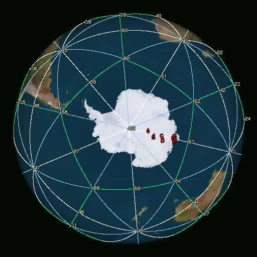
Attached is an Xplanet photo of Antarctica showing the Becker-Hagens grid lines. After getting this done, doesn't it make you think "HEY isn't this NEAT?" I labeled a few points close to the 62-53 grid line. Letter B is Lake Vostok, so you can plainly see that the heading comparison I did was correct. Points E through L got pasted over each other, but at least you know where they lie along the grid line.
While people are looking at Lake Vostok, perhaps they can investigate Mount McCarthy. It may turn out to be nothing, but perhaps buried under the mountain is something of value. Below is a list of what the letters mean. Tcdiff is the relative heading, meaning: comparing the 62-53 line heading with heading for 62-A, 62-B, 62-C, etc. It's just subtracting the two headings.
Latitude Longitude Pt1-Pt2 TCdiff City
-80.00, 102.00, 62-53, -1.200, A = Vostok Subglacial Highlands
-77.00, 105.00, 62-53, 1.802, B = Lake Vostok
-72.58, 106.23, 53-62, -3.660, C = McCarthy, Mount
-72.00, 106.00, 53-62, -3.640, D = Shmidt Subglacial Basin
-66.50, 105.00, 53-62, -5.000, E = Knox Coast/Knox Land
-66.03, 103.55, 53-62, -1.060, F = Conger Glacier
-66.03, 101.58, 53-62, 4.850, G = Remenchus Glacier
-65.97, 103.25, 53-62, -0.150, H = Glenzer Glacier
-65.95, 102.33, 53-62, 2.640, J = Tracy Glacier
-65.87, 102.58, 53-62, 1.910, K = Elliott, Cape
-65.28, 103.12, 53-62, 0.280, L = Bowman Island
-----------------------------------------------------------------
6/15/02 8:30:46 PM Pacific Daylight Time
SHERLOCK BILL
Kent,
I just had a major revelation of wisdom about Lake Vostok:
Remember how the coordinates are -77 latitude, 105 longitude (meaning
77S, 105E)? If you look at the physical Becker-Hagens grid once again
at http://www.vortexmaps.com or just
the coordinates at
http://www.akasha.de/~aton/TGGrid.html,
you'll see that Lake Vostok runs
EXACTLY through a grid line from node 62 (the South Pole) to node 54
(Kangaroo Fracture Zone). The difference in degree headings is
practically ZERO!
The implications of this may not be astounding, but it is to me. It's
been said before that the earth's grid energy would be reactivating next
year. I have a feeling the first clues about the beginning of this
reactivation was seen last year with Lake Vostok, with those ripples in
the ice.
THAT'S WHAT THE SECRECY IS ABOUT! It's the desperate, corrupt
military
and governments trying to somehow steal this free earth energy and be
selfish with it. But they won't be allowed to go too far with
accessing
this grid energy. Oh no. I have a feeling that between now and
next
year this time, corrupt people hiding down there will get what's coming
to them for trying to be selfish like that. Their own negative energy
will most likely come back to spank them in their behinds. It's their
own fault.
The jig is up now. Those in hiding in Antarctica might as well give
up
and confess that we know what you're up to! Tesla's probably out
there
in the cosmos, shouting at us: "FINALLY! You people are getting it!
And you people thought I was crazy with the Pierce Arrow car."
As another "gotcha" with the earth grid, see if you can ask the Indians
about the Cree and Blackfoot tribes. Look below as I find bunches of
places nearest to Node 08 of the Becker-Hagens grid, and find MEETING
CREEK (formerly Edensville):
Node 08 coordinates: 52.62N, 112.80W
Now use NRCan Map Search at
http://maps.nrcan.gc.ca/search/
to find
closest spots.
Coordinates given in the form of Deg:Min:Sec
Name, Province, FeatureType, DistKM, DistMI, Latitude, Longitude
Whitebrush Lake, Alberta, Lake, 3, 2, 52:37:00N, 112:51:00W
Mazy Lake, Alberta, Lake, 6, 4, 52:37:00N, 112:43:00W
Sittingstone Lake, Alberta, Lake, 9, 5, 52:35:00N, 112:55:00W
Rockeling Bay, Alberta, Bay, 7, 5, 52:33:00N, 112:48:00W
Meeting Creek, Alberta, Unincorporated area, 9, 5, 52:41:00N, 112:44:00W
Bashaw, Alberta, Town, 12, 7, 52:35:00N, 112:58:00W
Pelican Point, Alberta, Cape, 10, 7, 52:31:25N, 112:49:30W
Lynn Lake, Alberta, Lake, 12, 7, 52:31:00N, 112:45:00W
Boss Lake, Alberta, Lake, 11, 7, 52:31:00N, 112:46:00W
Boss Hill, Alberta, Mountain, 13, 8, 52:30:00N, 112:46:00W
Point Thirteen, Alberta, Cape, 13, 8, 52:31:00N, 112:53:35W
Dorenlee, Alberta, Unincorporated area, 14, 9, 52:42:00N, 112:57:00W
Erickson's Lake, Alberta, Lake, 14, 9, 52:42:15N, 112:38:30W
Pearce Lake, Alberta, Lake, 14, 9, 52:42:15N, 112:38:30W
Valley Lake, Alberta, Lake, 14, 9, 52:36:00N, 113:00:00W
Hatfield Lake, Alberta, Lake, 15, 10, 52:34:45N, 113:01:15W
Jarvis Bay, Alberta, Bay, 15, 10, 52:32:30N, 112:59:30W
White Sands, Alberta, Village, 17, 10, 52:28:00N, 112:49:00W
Donalda, Alberta, Village, 16, 10, 52:35:00N, 112:34:00W
Rochon Sands Provincial Park, Alberta, Conservation area, 18, 11,
52:28:00N, 112:53:00W
Edberg, Alberta, Village, 19, 12, 52:47:00N, 112:47:00W
Rochon Sands, Alberta, Village, 19, 12, 52:27:00N, 112:53:00W
Windsor Lake, Alberta, Lake, 19, 12, 52:36:00N, 113:05:00W
Buffalo Lake, Alberta, Lake, 20, 12, 52:27:00N, 112:54:00W
Here's an interesting comment about Meeting Creek, formerly called
Edensville, from
http://www.brrd.ab.ca/schools/history.htm
"In Cree, nukh-kwa-ta-to (Tyrrell). The Crees of the north and the
Blackfoot of the south frequently met here when on their buffalo hunts.
The hamlet was formerly known as Edensville."
How about we take a wild guess and say the Cree and Blackfoot Indians
knew about earth energies? Maybe the horses back then just knew where
to stop galloping because they sensed the energy coming together there?
Maybe just the Indians felt that and they needed the earth energies to
recharge their connection to the "great spirit". The truth will come
out when people get in touch with the earth, and and their own
consciousness. It would be great for a true indian to catch on to
what
I'm trying to type, and say "A-HA! That's IT!"
Lastly, here are some lists of places at the bottom of my note within
one "true course" degree of a Becker-Hagens earth grid line! And
there's more where that came from. The amount of Military sites
between
nodes 18 and 09 is amazing! Keep in mind that Washington DC runs
through this line! Then you got Three Mile Island, Hiroshima, Fort
Meade... Gee whiz: wanna suspect some secret electromagnetic UFO
experiments at a military facility? Just suspect any one of these 22
military sites between nodes 18 and 09.
These are partly fourth-dimensional ideas here... hopefully it won't fly
over people's head. Soon the corrupt government won't be able to hide
the free energy. And hopefully more people will get ready for this
4D
world and beyond.
Feel free to tell Bruce Cathie about this: he did study Hiroshima, you
know. Perhaps parts of his grid tie into the Becker-Hagens grid now.
I hope your intuition says this is a major story.
===========
Lat,Lon,PT1,PT2,TCdiff,NukeBlast
34.391697,132.4584077,14,04,1.06520,Hiroshima Bomb Site
Lat,Lon,PT1,PT2,TCdiff,Military Base
43.695229,-112.82209,08,17,0.10295,Idaho Falls Nuclear Training Center
42.749393,-76.866508,09,18,0.18240,Seneca Army Depot
40.794815,-91.245117,18,08,-0.36217,Iowa Army Ammunition Plant
32.003922,-81.579369,18,08,-0.34059,Fort Stewart
33.965412,-83.406914,18,08,-0.02606,"Naval Supply Corps School, Athens"
40.204418,-76.83886,18,09,-0.12591,New Cumberland Army Depot
38.86697,-77.017067,18,09,-0.79349,Fort Lesley J. McNair
38.87421,-76.997208,18,09,-0.72041,District Commandant (Navy Yard
38.975304,-77.030869,18,09,-0.83540,Walter Reed Army Medical Cente
39.038219,-76.969887,18,09,-0.61117,"Naval Surface Warfare Center,
White"
39.064919,-76.766289,18,09,-359.87900,Fort George G. Meade
39.245419,-76.526375,18,09,-359.03440,Baltimore Outport
38.34322,-77.03331,18,09,-0.89674,"Naval Surface Warfare Center, Dahlg"
40.229515,-76.982368,18,09,-0.58956,Mechanicsburg Ships Parts Control C
40.444901,-76.610336,18,09,-359.39810,Fort Indiantown Gap
39.199505,-76.570351,18,09,-359.18610,Curtis Bay Yard (Baltimore)
38.809422,-76.874046,18,09,-0.27217,Andrews Air Force Base
37.319725,-76.662483,18,09,-359.41370,Camp Peary
37.299522,-76.620209,18,09,-359.23180,Camp Peary
37.282257,-76.610092,18,09,-359.18720,"Naval Supply Center, Cheatham
Annex"
37.244595,-76.58065,18,09,-359.05740,"Naval Weapons Station, Yorktown"
37.135811,-76.603714,18,09,-359.14670,Fort Eustis
34.923126,-76.892715,18,09,-0.52326,"Marine Corps Air Station, Cherry
Po"
34.920998,-76.840355,18,09,-0.22782,"Marine Corps Air Station, Cherry
Po"
34.723942,-76.701538,18,09,-359.42940,Port of Morehead City
38.840809,-77.015678,18,09,-0.79036,Bolling Air Force Base
29.833288,-90.020844,18,17,0.71704,"Naval Air Station, New Orleans"
30.080133,-94.089493,18,17,-0.97931,Beaumont Outport Detachment
30.074734,-94.07962,18,17,-0.99432,Port of Beaumont
Lat,Lon,PT1,PT2,TCdiff,NuclearPowerPlant
37.10000000,129.38333330,14,04,0.12464,ULCHIN UNIT 1
57.25000000,12.11666667,11,02,-0.70442,RINGHALS-1
47.81666667,31.21666667,02,01,-0.13366,SOUTH UKRAINE-1
30.45000000,120.93333330,13,14,0.14177,QINSHAN-1
37.18333333,-76.68333333,18,09,-359.49540,SURRY-1
40.15305556,-76.72500000,18,09,-359.75590,THREE MILE ISLAND-1
35.60277778,-84.79027778,18,08,0.86012,WATTS BAR-1
41.78333333,123.38333330,04,14,0.52071,LIAONING-1
33.20000000,133.13333330,14,04,-0.94612,KUBOKAWA
Lat,Lon,PT1,PT2,TCdiff,Observatory
42.430533413,11.170000000,02,20,0.76825,Monte Argentario
41.495474930,-91.532000000,08,18,-0.70150,"Van Allen Observatory, Iowa
City"
33.674325058,132.944200000,14,04,0.24165,Kuma Kogen
34.221330284,132.220800000,14,04,-0.47140,Ootake
35.989190255,139.150000000,14,05,-0.24720,Chichibu
36.006070228,139.194400000,14,05,-0.02763,Tokyo-Dodaira
35.388449340,139.213300000,14,05,-359.92930,Hadano
36.098851021,139.235300000,14,05,-359.82770,Yorii
36.228292406,139.246700000,14,05,-359.77550,Honjo
36.481921392,139.263500000,14,05,-359.70340,Kurohone
36.297261350,139.329200000,14,05,-359.38370,Kamihoriguchi
35.813579213,139.082800000,14,05,-0.59164,Okutama
36.124841535,139.108000000,14,05,-0.44767,Nagatoro
35.689766380,139.039200000,14,05,-0.82391,Uenohara
36.245196167,139.336700000,14,05,-359.34410,Ojima
31.689025177,-110.884600000,17,18,0.59037,"Whipple Observatory, Mt.
Hopkins"
31.670284514,-110.580800000,17,18,0.92985,"Grasslands Observatory,
Tucson"
34.205364449,-83.835800000,18,08,-0.74373,Oakwood
42.118464195,-77.076700000,18,09,-0.76563,"Collins Observatory, Corning
Community College"
38.920448204,-77.065500000,18,09,-0.96563,"U.S. Naval Obs., Washington
(since 1893)"
38.894248303,-77.050600000,18,09,-0.91370,"U.S. Naval Obs., Washington
(before 1893)"
38.936507523,-77.000000000,18,09,-0.72635,"Catholic University
Observatory, Washington"
40.164843375,-76.815000000,18,09,-0.04877,Etters
42.417298559,-76.494200000,18,09,-359.17330,"Ford Observatory, Ithaca"
-31.276840638,149.066100000,44,45,-0.43089,Siding Spring Observatory
-31.278334839,149.212300000,44,45,-0.33841,"Rainbow Observatory, near
Coonabarabran"
-31.334654315,151.046100000,44,45,0.92268,Loomberah
-31.276840638,149.066100000,44,45,-0.43089,Siding Spring Observatory-DSS
-40.237487254,175.470000000,45,55,-0.87221,Palmerston North
![]() LAKE VOSTOK
LAKE VOSTOK
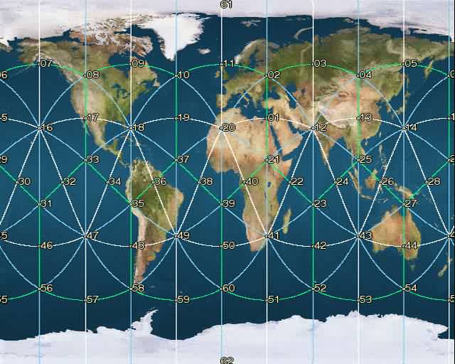
I have been studying the 62-node Becker-Hagens earth grid, which can be
seen at several web sites such as
http://www.ascension2000.com/Convergence/9918.html
or
http://www.vortexmaps.com or
http://www.ping.be/beeldschoon/biogeometry/gridlijnen/grids_uk.html
as
well. I'm wondering if this grid has a link to Ambilac's recent
article
(insert link to recent article here), because both GIZA and BETHLEHEM
are along the lines in this grid. I'm also curious about Lake Vostok,
but that's a whole 'nother can of worms.
Hopefully you won't mind me rambling on about what I've done here.
If
I've made a mistake, that's okay because I'm a student too, even if I
seem like a teacher. It took a long time to simply understand the
exacting process to find a "true course", or "heading" between two
points.
I've fine-tuned a system on my own, where I compare headings between
grid points to find places within one degree of a grid line. The
lines
form three distinct distances between grid nodes. I did all this work
because no one else on the internet seemed to ask the question of what
places can be found along the Becker-Hagens earth grid lines (or any
similar 62-node grid)? So far I have 7524 places along 100 of
the line
segments in this grid, but to get that many points, I had to plow
through what must be 200,000 points... I haven't counted all my 40 megs
of database tables. The photo of the node numbers and line segments
is
in the first link I gave you (Ascension2000). My web site is still
under construction, but I'll have an ASP script set up to query a
database and show people lists of points. It's my first attempt at
understanding ASP, so it was a challenge for me to factor in all the
issues related to ASP.
However, in order to fine-tune this heading-comparision process, I had
to correct some points as given in several locations around the web.
There was an article by Richard Dannelley which had errors in 8 of the
62 points, and the "beeldschoon" link above has errors in 3 of the nodes
too. Yet another link has errors due to copying this same data around
and around without checking distances between points.
BEHOLD! Below is my corrected list of coordinates for all 62 nodes
of
the Becker-Hagens earth grid. The only place on the internet you'll
find this correct data is in this note right here, most likely. That
is, until other sites fix their node point errors. Note: for points
61
and 62, I couldn't use 90 or -90 degrees latitude because the standard
heading formula doesn't work for the poles. So I had to "cheat" and
use
a point extreeeeemly close to the poles, so I would end up with proper
headings. Cheating like this was accurate enough to find places in
Antarctica within one degree of a grid line, so that's all I needed.
Pt Lat Lon
01 31.7200 031.2000
02 52.6200 031.2000
03 58.2800 067.2000
04 52.6200 103.2000
05 58.2800 139.2000
06 52.6200 175.2000
07 58.2800 -148.8000
08 52.6200 -112.8000
09 58.2800 -076.8000
10 52.6200 -040.8000
11 58.2800 -004.8000
12 26.5700 067.2000
13 31.7200 103.2000
14 26.5700 139.2000
15 31.7200 175.2000
16 26.5700 -148.8000
17 31.7200 -112.8000
18 26.5700 -076.8000
19 31.7200 -040.8000
20 26.5700 -004.8000
21 10.8100 031.2000
22 00.0000 049.2000
23 -10.8100 067.2000
24 00.0000 085.2000
25 10.8100 103.2000
26 00.0000 121.2000
27 -10.8100 139.2000
28 00.0000 157.2000
29 10.8100 175.2000
30 00.0000 -166.8000
31 -10.8100 -148.8000
32 00.0000 -130.8000
33 10.8100 -112.8000
34 00.0000 -094.8000
35 -10.8100 -076.8000
36 00.0000 -058.8000
37 10.8100 -040.8000
38 00.0000 -022.8000
39 -10.8100 -004.8000
40 00.0000 013.2000
41 -26.5700 031.2000
42 -31.7200 067.2000
43 -26.5700 103.2000
44 -31.7200 139.2000
45 -26.5700 175.2000
46 -31.7200 -148.8000
47 -26.5700 -112.8000
48 -31.7200 -076.8000
49 -26.5700 -040.8000
50 -31.7200 -004.8000
51 -58.2800 031.2000
52 -52.6200 067.2000
53 -58.2800 103.2000
54 -52.6200 139.2000
55 -58.2800 175.2000
56 -52.6200 -148.8000
57 -58.2800 -112.8000
58 -52.6200 -076.8000
59 -58.2800 -040.8000
60 -52.6200 -004.8000
61 89.9990 000.0000
62 -89.9990 000.0000
NOW: because the recent Ambilac article mentions BETHLEHEM and GIZA, I
thought I'd share what I found so far along the lines related to those
two places. I have 13 places along the 01-21 line segment of the
Becker-Hagens grid. "TCdiff" means: the "relative heading" between
two
true courses, or headings, is less than one degree. In plainer
English,
it means, if one plane flew from point A to point B, and another plane
flew from point A to point C, exactly at the same time, these planes
would be mostly within eyesight of each other. Meaning, both flight
paths are essentially the same. It took a long time for me to get
this
system down pat, so I don't assume a new person to understand all this
at once.
Country,Place,Type,Lat,Lon,PT1,PT2,TCdiff
Sudan,EDB: ELDEBBA DABBA,AirportWorld,18.250000,31.250000,21,01,0.36671
SUDAN,WADI HALFA,RBSN,21.920000,31.350000,01,21,-0.81751
ABUS,Abu Simbel,NEIC,22.250000,31.137199,01,21,0.35327
Egypt,Abutig,CitiesEurope,27.100000,31.283333,01,21,-0.92094
EGYPT,ASYUT,RBSN,27.200000,31.170000,01,21,0.33858
Egypt,Asyut,CitiesEurope,27.233333,31.116667,01,21,0.94711
Egypt,El-Maimun,CitiesEurope,29.233333,31.200000,01,21,0.00000
AUT,El`Aiyat,NEIC,29.666000,31.180000,01,21,0.48485
Egypt,Pyramids of Abusir,CitiesEurope,29.850000,31.233333,01,21,-0.88591
Egypt,Harrania,CitiesEurope,30.033333,31.233333,01,21,-0.98034
EGYPT,GIZA,RBSN,30.050000,31.220000,01,21,-0.59401
EGYPT,EMBABA,RBSN,30.070000,31.180000,01,21,0.60109
Egypt,Benha,CitiesEurope,30.466667,31.183333,01,21,0.65673
Then I have 50 places along the 01-12 line segment of the same grid
system:
Country,Place,Type,Lat,Lon,PT1,PT2,TCdiff
ISRAEL,AFRIDA,Seaports,31.650000,34.533333,01,12,0.54255
ISRAEL,ASHKELON,Seaports,31.650000,34.533333,01,12,0.54255
ISRAEL,ASHQELON,Seaports,31.650000,34.533333,01,12,0.54255
Israel,Ashqelon,CitiesEurope,31.666667,34.583333,01,12,0.17697
Israel,Bet Guvrin,CitiesEurope,31.616667,34.900000,01,12,0.91214
GVI,Bet Guvrin,NEIC,31.632000,34.909000,01,12,0.62718
ZNH,Zanoah,NEIC,31.677000,35.000000,01,12,-0.23206
Israel,Khadr,CitiesEurope,31.700000,35.150000,01,12,-0.69266
Israel,Artas,CitiesEurope,31.683333,35.183333,01,12,-0.42243
Israel,Beit Jala,CitiesEurope,31.716667,35.183333,01,12,-0.98620
Israel,Bethlehem; Beit
Lahm,CitiesEurope,31.700000,35.200000,01,12,-0.71007
Israel,Beit Sahur,CitiesEurope,31.700000,35.216667,01,12,-0.71586
DRGI,Dragot,NEIC,31.591000,35.391998,01,12,0.97402
JD,QUEEN ALIA INTL; OJAI,RadioWorld,31.666667,35.966667,01,12,-0.49484
JORDAN,QUEEN_ALIA_INTL,RBSN,31.670000,35.970000,01,12,-0.54332
JORDAN,QUEEN ALIA AIRPORT,RBSN,31.670000,35.980000,01,12,-0.54742
MDSJ,Mudaysisat,NEIC,31.632000,36.251999,01,12,-0.15039
IRAQ,BASRAH/SHAIBAH,RBSN,30.420000,47.650000,01,12,0.97353
IRAQ,KHAWR AZ ZUBAYR,Seaports,30.400000,47.750000,01,12,0.99570
IRAQ,KHOR AZ ZUBAYR,Seaports,30.400000,47.750000,01,12,0.99570
Iraq,BSR: BASRA INTL,AirportWorld,30.550000,47.766667,01,12,0.38362
IRAQ,BASRAH,RBSN,30.570000,47.780000,01,12,0.29591
BSR,Basra,NEIC,30.600000,47.799999,01,12,0.16453
IRAQ,BASRA,Seaports,30.500000,47.816667,01,12,0.55668
IRAQ,BASRAH,Seaports,30.500000,47.816667,01,12,0.55668
IRAQ,BUSREH,Seaports,30.516667,47.850000,01,12,0.47145
IRAQ,NAHR ABU EL FLUS,Seaports,30.450000,48.033333,01,12,0.63430
IRAQ - SHATT AL ARAB,ABU FLUS,Seaports,30.450000,48.033333,01,12,0.63430
IRAN - SHATT AL
ARAB,KHORRAMSHAHR,Seaports,30.433333,48.166667,01,12,0.62502
IRAN - SHATT AL ARAB,HARTA
POINT,Seaports,30.366667,48.183333,01,12,0.87660
Iran,ABD: ABADAN,AirportWorld,30.366667,48.233333,01,12,0.84787
IRAN,ABADAN_INTL_AIRPORT,RBSN,30.370000,48.250000,01,12,0.82533
IRAN,ABADAN,RBSN,30.370000,48.250000,01,12,0.82533
IR,ABADAN INTL AIRPORT;
OIAA,RadioWorld,30.366667,48.250000,01,12,0.83832
IRAN - SHATT AL ARAB,ABADAN,Seaports,30.333333,48.283333,01,12,0.94881
IRAN,KHOMEINI BANDAR,Seaports,30.450000,49.083333,01,12,0.06212
IRAN,BANDAR SHAHPOUR,Seaports,30.450000,49.083333,01,12,0.06212
Iran,MRX: BANDAR MAHSHAHR
MAHSHAHR,AirportWorld,30.533333,49.166667,01,12,-0.29134
IRAN,BANDAR KHOMEINI,Seaports,30.466667,49.183333,01,12,-0.05242
IRAN,BANDAR MAHSHAHR,Seaports,30.466667,49.183333,01,12,-0.05242
IRAN,BANDAR MASHUR,RBSN,30.500000,49.200000,01,12,-0.18468
IRAN,BANDAR MASHAHR,RBSN,30.550000,49.200000,01,12,-0.37016
IRAN,KHOWRE SOLTANI,Seaports,29.983333,50.783333,12,01,-0.89207
IR,GACH SARAN(PRIVATE);
OIAH,RadioWorld,30.350000,50.816667,12,01,0.53572
IRAN,GACH SARANI,RBSN,30.350000,50.820000,12,01,0.53780
IRAN,GACH_SARAN(PRIVATE),RBSN,30.350000,50.820000,12,01,0.53780
IR,SIRJAN; ,RadioWorld,29.466667,55.716667,12,01,0.60229
IRAN,SIRJAN,RBSN,29.470000,55.720000,12,01,0.62366
IRAN,BAFT,RBSN,29.230000,56.580000,12,01,0.27277
IR,BAFT; ,RadioWorld,29.233333,56.583333,12,01,0.29588
Finally, this is a summary of how many places I have along the
Becker-Hagens earth grid. There are 100 line segments covered, for
a
total of 7524 places. All the points were gathered from freely
available lists of coordinates, wherever I could find them. A GPS
expert probably could've helped me track down a more comprehensive
database of coordinates, but I thought it was more rewarding to hunt
down lists on my own. All of these places are within one
heading-degree
of a grid line, meaning: these places are "in the path of" a grid line.
Note how I stated above that I have 13 places between 01 and 21; thus,
the fourth entry below (1, 21) shows 13. Keep in mind: some of
places
have the first point as the closest point (PT1); other places have the
SECOND point as the closest. That's because some places are closer
to
one point, where others are closer to the other end of the line segment.
Also note: with over 2000 places listed between nodes 8 and 18, I think
I've just about covered every inch of that line segment that cuts across
the US. I've found that the United States puts lists of coordinates
together more efficiently than other countries I've seen. It's hard
to
say, search for CHINA and get neat little lists of points in a format
that looks like the ones in the US. For other countries I had to be
creative and use lists of weather stations which would be in several
locations around the world. The most difficult list to put together
was
telescope observatories, because I had to convert the insane PARALLAX
coordinates to latitude and longitude. I hope I never have to use
parallax formulas again, because astronomy is not my strong point.
But
I try to comprehend any subject in order to find the truth.
PT1 PT2 Count
1 2 12
1 12 50
1 20 12
1 21 13
2 3 13
2 11 47
2 12 30
2 20 154
2 61 44
3 4 6
3 12 25
3 61 9
4 5 8
4 12 16
4 13 5
4 14 97
5 6 21
5 14 107
5 61 6
6 7 33
6 61 2
7 5 1
7 8 40
7 61 101
8 9 7
8 16 16
8 17 619
8 18 2058
8 61 4
9 18 1466
10 18 25
11 10 1
11 20 137
12 13 23
12 21 32
12 24 47
12 25 20
13 14 15
13 25 14
14 25 11
14 26 34
14 28 11
17 16 3
17 18 1101
17 33 8
18 33 55
18 34 34
18 35 64
18 36 15
20 10 3
20 19 2
20 38 12
20 39 17
20 40 7
21 22 2
21 40 3
21 41 19
22 23 1
25 26 11
25 43 4
26 43 7
27 26 1
27 28 39
27 43 29
27 44 9
28 29 1
29 16 1
31 46 2
35 36 9
35 49 15
36 49 13
37 49 17
40 39 1
40 41 20
41 22 5
41 23 5
41 39 8
41 50 14
41 51 2
41 60 5
43 44 15
44 45 52
44 54 3
45 28 32
45 55 51
48 49 47
48 58 2
51 62 34
52 62 99
53 62 2
54 62 15
57 62 42
58 49 6
58 62 21
60 62 66
61 4 10
61 9 1
62 55 25
62 56 30
62 59 15
I found these links to add in there somewhere:
Ascension Grid Activation
http://www.lightworker.com/HotSpots/gridactivation.shtml
For Whom The Bell Tolls:
http://www.angelfire.com/mt/mandalaoflight/articles/fall99/bell.html
Dowsing Down Under - Searching for Grid Point 44:
http://www.britishdowsers.org/EEG_site/articles/aud2001_issue_21/Dowsing%20Down%20Under2.htm
World Grid - lots of related links:
http://www.deepinfo.com/WorldGrid.htm
PhiGrid - program available to draw grid lines!
http://members.telering.at/t.faltejsek/
THE LAW OF SEVEN IN RELATIONSHIP TO THE GRID OF PLANET EARTH:
http://www.wiolawapress.com/lawof.htm
Note the green ozone photo here.
The "Message of Cydonia":
http://www.enterprisemission.com/message.htm