 |
Subject: Fwd: Re: Dense fogs in Valles Marineris Mars.
Date: 4/5/2005 11:32:33 AM Pacific Standard Time
Here's who posted it--with some more info. |
|
Subject: Fwd: Re: Dense fogs in Valles Marineris Mars.
Date: 4/5/2005 11:32:33 AM Pacific Standard Time
Here's who posted it--with some more info. |
In article ---wrote:
[snip]
> Anyway, regardless of how far above 10 deg C water can remain liquid
in
> Valles Marineris, it is a sure thing that pools of liquid water are
a
> real possibility there. Given the photo referenced earlier, showing
the
> fog and the apparent pools of blue water, it is my guess that Valles
> Marineris was carved by underground icemelt flowing into the bottom
of
> the canyon, with the source of heat being the magma chamber under the
> nearby Tharsis volcanos. I would suggest that geothermal heating from
> magma near Valles Marineris melts buried ice from an ancient Martian
> sea, and that liquid water then flows out into the bottom of the canyon.
> Based on the above calcs, such water could remain liquid at least to
10
> deg C and, arguably, to 12 deg C. Since solar heating would seldom push
> the summer temperature above 10 deg C, and since water flows entering
> the canyon from vents at the bottom would cool quickly by evaporation
to
> temperatures at which they would remain liquid, it follows that if
> steady inflows of geothermally heated water are available at the bottom
> of the canyon, pools of liquid water will exist there.
>
> Interestingly, there is a photo of a portion of Reull Vallis, one of
the
> canyons feeding into Valles Marineris from the north, which appears
to
> show a lake of liquid water more than 100 km in length, and averaging
15
> or 20 km in width. See
>
http://www.esa.int/export/SPECIALS/Mars_Express/SEMAZ625WVD_1.html
to
> view this photo.
>
> If you see nothing but bare rocks, then I suggest that you note the
> following facts:
>
> (1) If there is no wind or other source of disturbance, the surface
of
> water is as flat as a sheet of glass.
>
> (2) If there are no suspended particulates, water is perfectly
> transparent.
>
> (3) The intrinsic color of water is blue, a fact that is revealed
> progressively, as the water becomes deeper and deeper. [See
> http://webexhibits.org/causesofcolor/5B.html.]
>
> (4) The sky is not blue on Mars, so there is no opportunity for
> reflection to make shallow water appear to be blue, as often happens
on
> Earth. Thus if water on Mars shows blue, it will be deep water only.
>
> With those facts in mind, I suggest that you download the hi-res tiff
> version of the above referenced photo and study it carefully. If you
do,
> you will note that a distinct water line is visible most of the way
> around the lake, and that as the water gets deeper and deeper, its blue
> coloration is progressively revealed.
>
> I say that's a lake--a huge one, as a matter of fact.
>
> Here is how such a lake would come into being:
>
> (1) An upwelling of hot water from a deep geothermal source would spread
> out on the bottom of the canyon.
>
> (2) Atmospheric pressure at the bottom of the canyon would be roughly
> 8.49 mmHg and, if the air temperature were above roughly 10 to 12 deg
C,
> vaporization by boiling would promote rapid cooling of the water and
> would increase its salinity.
>
> (3) Over the eons, the salinity of the remaining water would be
> progressively increased, each time the atmospheric temperature rose
high
> enough to cause a repetition of (2), above.
>
> (4) Eventually, the salinity of the water, due to the buildup of
> multiple solutes, would be so high that boiling would seldom occur.
>
> Conclusion: the photo of the fog shows an episode where the air
> temperature rose high enough to promote boiling; and the photo of the
> lake in Reull Vallis shows the normal case, where the air temperature
is
> *not* high enough to promote boiling.
>
> Interestingly, a continuation of such boiling episodes for millions
or
> billions of years would result in total saturation of the water, and
> continued "salting out" of minerals onto the bottom. The result would
be
> a buildup of immense mineral deposits in the locations where the
> repeated boiling episodes were occurring. The area beneath and around
> the lake at Reull Vallis, for that reason, may very well contain some
of
> the richest surface mineral deposits in the Solar System.
>
> There probably aren't any fish in the lake, however. :-)
>
> --}***
[snip]
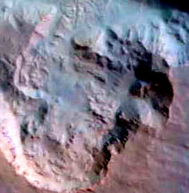
[Note: the following analysis concerns the lake shown in the Mars photo
at the following link:
http://www.esa.int/export/SPECIALS/Mars_Express/SEMAZ625WVD_1.html.]
According to the remarks beneath the photo, the area shown is 100 km
wide. Using that as my scale, I estimate that the lake in Reull Vallis
is at least 91 miles long, before it goes off of the photo (at both
ends). Its width at its narrowest point is 8.1 miles and at its widest
point is 38 miles. By way of contrast Lake Travis, a large lake in
Texas, is 60 miles long and 4.5 miles wide at its widest point. Thus the
Reull Vallis lake is huge!
How deep is it? Well, one strong hint is provided by the deep blue
fading to black along the bottom of the lake. As light passes through
clear water, it is attenuated by the water itself, which acts as an
absorbing medium. As the light passes deeper and deeper into the water,
it is attenuated in much the same way that atmospheric pressure is
attenuated by increasing altitude. The formula is as follows:
I = I0e^-ad
In the above, I is the intensity of the light after passing a distance d
through the absorbing medium, I0 is the intensity of the light when the
passage began, e is the base of natural logarithms, a is the absorption
coefficient of the light, and d is the distance of passage through the
medium.
Since the absorption coefficient varies in a very rough direct
proportion to the wavelength of the light, being very high for the long
wavelength (red) end of the spectrum, and very low for the short (blue)
end, we can calculate the depth where, say, 99% of the green light has
been absorbed, and that will be the depth beyond which, as a practical
matter, only blue light will reach the bottom. Hence the bottom will
appear very light blue when seen through water that is slightly deeper
than that, and progressively darker shades of blue as we go deeper
still, and, finally, when 99% of the blue light will itself have been
absorbed, only very dark blues will show, with black beyond. Since the
attenuation coefficient for the most energetic deep green light is .0162
per meter of distance travelled through the water, that is what we will
use. Using G to represent the intensity of the incoming green light, we
obtain:
.01G = Ge^-.0162d
.01 = e^-.0162d
ln .01 = -.0162d
-4.61 = -.0162d
d = 285 meters
So 99% of the deep green will be gone when the light has travelled
through 285 meters of water. Since the light comes from the sun, enters
the water, travels to the bottom, reflects, and then travels back to the
surface, the depth of the water when only a hint of green remains in the
blue will be d/2 = 230/2 = 142 meters.
At what depth will 99% of the deep blue be gone? Well, the absorption
coefficient of the most energetic deep blue light in pure water is
.00478 per meter of distance. Using B to represent the intensity of the
incoming blue light, we obtain:
.01B = Be^-.00478d
That leads to:
d = 964 meters
The lake depth is half of that, or 482 meters, as the deep blue fades
into black.
Conclusion: the lightest blue on the bottom of Reull Vallis Lake is at
depths of about 142 meters, and the darkest blues are at depths of about
482 meters. Below those levels, in the blackness, lies what are
doubtlessly lengthy passageways within a hydrothermal vent system,
leading eventually back to a magmatic heat source. That source could
either be a magma chamber close to the surface, with layers of rock
separating its top from buried ice, or it could be an active volcano
erupting periodically beneath a vast sheet of buried ice. The latter, in
my opinion, is far more likely, because such a postulate explains
virtually everything about Valles Marineris itself.
To elaborate, note that Valles Marineris begins near the Tharsis
volcanos, and slopes downhill away from them. If there were a vast ice
sheet from a frozen ancient sea, buried beneath surface accumulations of
rock and dust, and if an active volcano popped up under such an ice
sheet, its eruption would cause a collapse of the ice sheet at some
nearby point, wherever the overburden was weakest, and the overburden
would cave in on top of it. The result would be a lake of icemelt that
would boil in the low atmospheric pressure, melt nearby ice, and
gradually work its way downhill, collapsing the overburden as it did so.
Over hundreds of millions of years, such a process would form a vast
canyon system very much like Valles Marineris.
That, then, is my best guess as to what is going on here: the bottom of
Valles Marineris is like the bottom of a teakettle which has repeatedly
been used to boil water for hundreds of millions of years, and has never
been cleaned. It contains a vast accumulation of "salted out" minerals,
and those minerals, in turn, rest on what was once the bottom of an
ancient sea. The walls of the canyon, by this reasoning, are going to
turn out to be mostly surface rocks that have fallen down as the ice
melted away beneath them, and, further back, behind the walls and under
the rocky overburden, lies the ice of the ancient sea itself. How thick
is that ice sheet? Several kilometers, I should think.
So there you have it! :-)
[Notes:
(1) I took my absorption coefficients from R. M. Pope and E. S. Fry,
"Absorption spectrum (380?700nm) of pure water. II. Integrating cavity
measurements," Appl. Opt., 36, 8710--8723,
(1997).
(2) The water in Reull Vallis Lake is not pure water. Unknown
concentrations of unknown solutes are dissolved in it. Hence the above
calculations are only estimates.]
--