For Plattsburgh: there's EXCELON! We got a bite! Reel it in!
SHERLOCK BILL
4/20/02 8:45:16 AM Pacific Daylight Time
There's only one spot I found for nuclear stuff mixed with Plattsburgh,
NY: EXELON! Details at the bottom of the page. As far as the
usual
REACTORS go, the closest reactor to Pittsburgh is Gentilly-2 in
Becancour, Quebec in Canada. REACTORS closest to Plattsburgh, NY:
(PB_Dist is distance from Plattsburgh, NY in nautical miles.)
Latitude Longitude PB_Dist City
46.40000000 -72.31666667 112.655
GENTILLY-2
46.40000000 -72.31666667 112.655
GENTILLY-1
42.72888889 -72.92888889 120.400 YANKEE
NPS
42.78027778 -72.51583333 122.109 VERMONT
YANKEE
43.52388889 -76.39833333 145.143
FITZPATRICK
43.52222222 -76.41000000 145.633 NINE
MILE POINT-2
43.52222222 -76.41000000 145.633 NINE
MILE POINT-1
42.89805556 -70.85138889 156.122
SEABROOK-1
43.95055556 -69.69611111 167.397 MAINE
YANKEE
43.27777778 -77.30888889 186.996 R.E.
GINNA
41.48194444 -72.49916667 197.521
CONNECTICUT YANKEE
46.20000000 -77.70000000 200.108 NPD
41.27138889 -73.95250000 206.846 INDIAN
POINT-1
41.27138889 -73.95250000 206.846 INDIAN
POINT-2
41.27138889 -73.95250000 206.846 INDIAN
POINT-3
41.94444444 -70.57944444 207.481
PILGRIM-1
41.30861111 -72.16805556 211.114
MILLSTONE-3
41.30861111 -72.16805556 211.114
MILLSTONE-1
41.30861111 -72.16805556 211.114
MILLSTONE-2
43.88333333 -78.70000000 230.547
DARLINGTON-1
43.88333333 -78.70000000 230.547
DARLINGTON-4
43.88333333 -78.70000000 230.547
DARLINGTON-2
43.88333333 -78.70000000 230.547
DARLINGTON-3
Plattsburgh AFB closed in 1995, and reopened as a regular airport (PBG).
WITH AERIAL PHOTOS!
http://asuwlink.uwyo.edu/~jimkirk/atlas.html
NO PHOTOS...
http://www.siloworld.com/COORDINATES/LOCAL.htm
CLOSEST ATLAS Missile sites to Plattsburgh:
First number is Lat. (Deg-Min-Sec), then Long. (Deg-Min-Sec)
Plattsburgh AFB Missile Site #04 44-20-34 073-22-12
Plattsburgh AFB Missile Site #06 44-27-37 073-38-33
Plattsburgh AFB Missile Site #07 44-32-50 073-58-30
Plattsburgh AFB Missile Site #08 44-36-05 073-51-22
Plattsburgh AFB Missile Site #09 44-46-15 073-49-22
Plattsburgh AFB Missile Site #10 44-50-37 073-59-18
Plattsburgh AFB Missile Site #11 44-54-44 073-49-04
Plattsburgh AFB Missile Site #12 44-58-05 073-38-02
http://www.mysticbroadcast.org/mindcontrol.html
Where are the Chemtrail aircraft based? ...PLATTSBURGH, AFB
Plattsburgh AFB is located at 44 deg. 40'N, 073 deg. 28'W
Or in decimal format: Lat: +44.657500; Longitude: -073.464719
Plattsburgh AFB is an EPA Superfund site, meaning they're a little
"dirty":
http://www.epa.gov/superfund/sites/rodsites/0202439.htm
Besides PBG, there's another airport in Plattsburgh NY:
ADIRONDACK AIRPARK ESTATES (long.: -73.857919; lat.: 44.609211)
PLATTSBURGH INTL airport (PBG) (long.: -73.468127; lat.: 44.650942)
HEY! Towers kill birds too! There are 5 in Plattsburgh NY:
http://www.towerkill.com/NYR/nytowers.html
City Latitude
Longitude Tower #'s Hgt.(ft.)
PLATTSBURGH 44 34 28N 073 40 29W
TOWERS 2 982
PLATTSBURGH 44 41 43N 073 52 59W
TOWER 445
PLATTSBURGH 44 44 42N 073 26 23W
TOWER 320
PLATTSBURGH 44 34 27N 073 26 52W
TOWERS 3 260
PLATTSBURGH 44 41 49N 073 26 59W
TOWER 200
And 3 Plattsburgh towers are listed here in case anybody cares:
http://www.geocities.com/amlogbook/mcities.htm
FINALLY: Here's the BIG FISH you were waiting for!
http://www.exelonpowerlabs.com/
Exelon PowerLabs (merger of PECO Energy and Unicom Corp, and formerly
PECO PowerLabs)
What do they do? Click here:
http://www.exelonpowerlabs.com/services.htm
"Our Plattsburgh facility is located at the old Plattsburgh Air Force
Base (aka PARC) in the North Country of New York State."
Exelon PowerLabs
New England Division
2801 Colorado Street
Plattsburgh, NY 12903
518-566-6450
Can you believe that? Right in the old Plattsburgh AFB!
MORE:
This doesn't sound like Mother Nature works here. Another oddity about Plattsburgh pointed out in a chemtrail forum.
http://www.nexiabiotech.com/HTML/research/index.shtml
Nexia Biotechnologies USA Inc
82 Nexia Way
Plattsburgh NY, USA 12903
"Nexia biotechnologies is one of the world's largest producer of authentic recombinant spider silk, and a leading North American animal transgenic company. Nexia manufactures biomaterials and therapeutic proteins in the milk of transgenic dairy goats"
Other businesses in a large area circling Plattsburgh:
http://www.lakechamplain.com/services/directory/browsecategory.cfm?subcategory=93
Subj: Antipode of Plattsburgh area quake
Date: 4/20/02 9:00:24 PM Pacific Daylight Time
SHERLOCK BILL
Kent: was thinkin' about that Plattsburgh NY quake... they said it was centered around 44.51N 73.66W. The antipode of that spot is exactly halfway around the earth, like you shoved a pencil from one side and came out the opposite side of the earth in the opposite hemisphere. Anyway: the other side of the earth for that quake is 44.51S, 106.34E. If you look at a POLAR projection of the earth, it's easier to see how these two points line up.
The point is: if you think about how Tesla wrote about quakes, you can cause quakes on the other side of the earth by hitting the antipode on the other side of the planet. Remember that? Well this spot is southeast of Australia, where no island exists, so most likely, this quake was caused locally, underground. But I'm just guessing, that's all.
If some secret power had an antenna buried southeast of Australia, and made use of Tesla's theories, maybe this quake could've been caused stealthily.
Oh well... I'm just throwing around ideas.
Date: 4/21/02 9:19:34 PM Pacific Daylight Time
Did you notice from the "Scalar Wars" file that it mentions Western Australia being used as a 'testing ground' for Scalar weapons? This would match Tesla's opposite 'pole' for Plattsburg.
http://www.nexusmagazine.com/bskies2.html
Date: 4/21/02 2:06:00 PM Pacific Daylight Time
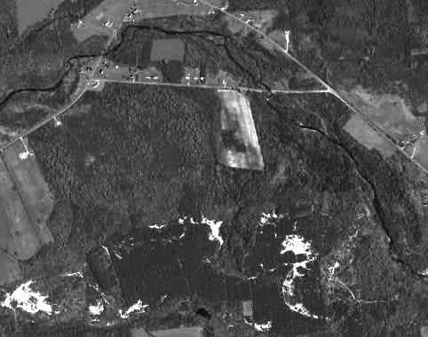
Aerial photo for quake coordinates of 44.51N 73.66W is not much to look at, just trees. The Terraserver MSN site says the area is "3 km NE of Stevens Landing, New York". Photo is attached
EDITOR'S NOTE: Hitler born April 20, 1889, Braunau, Austria
"Eagle's Nest" was built as a 50th birthday present to Adolf Hitler from the Nazi Party.
EDITOR: MORE TRACKING AROUND ON SAT IMAGES
http://pirs.mvr.usace.army.mil/fuds/m-p/plattms7/oe/asr/findings/21.pdf
Chemtrails, HAARP, and Mass Mind Control
Re: OPEN LETTER TO YOU FROM TRANSPORT PILOT
1) Where are the Chemtrail aircraft based?
Edwards, AFB; Point M. Naval Station (UH1H, helicopters); Nellis, AFB; Tucker, AFB; PLATTSBURGH, AFB; Andrews, AFB; Hickam, AFB; Kirtland, AFB; Langley, AFB (these flights originiating out of Langely are for experimental "soups." And for laying in on the tri-state area around DC); Peterson, AFB; Osan, AFB.
Date: 4/21/02 6:44:34 AM Pacific Daylight Time
It is the Earth that flips, not the electromagnetic gravitional negetive and positive charges.
Magnetic north is an X lociation in the Canadian ice pack that moves, where research will show there was a deviation between pole star true north(Polaris) and magnetic north in the 16th and 17th century of ONLY 14 Degrees. Today, this deviation is +17degrees from true north to magnetic north.
P.S.
LIVING IN UP-STATE N.Y., and being 30 miles from the epa-center of the 5.1/5.5 so-called earthquake, which occurred on april 20,2002 @ 6:50 A.M., (Keesville, N.Y.,) WHERE MY BROTHER is living, indicates that this was no normal earthquake. It came in- up and to the north. All of the nicknacks on the picture window sill were pushed or moved north to south, didn't shake or break nor was there any dammage what so ever........Thoughts like my furnace blew up, what is in the sky ? north direction, or where is the evidence of any movement at all from a 5.1 quake.
People who were awake went to there north windows face direction and looked up in the direction where they thought the sounds were coming.
I slept through both the 6:50 a.m., and 7;15 a.m. 4.0 ? yet felt the 2.8 at 7:45 a.m. wave. any comments ?
http://www.newscientist.com/news/news.jsp?id=ns99992152
P.P.S.
I often have woundered where the fuel exists to feed this moulten core of iron ore? if the earth and universe is 4 billion years old, how come the core of the earth is still in existence at all and where is all of the iron ore coming from, to feed the fires and cause these volcanic erruptions? .
Unless this is a parabolic representation, where the sun's rays play onto the back side of the interior earth continously heating the center of the earth, as the earth produces more iron ore to melt and keep the cycle going ..................until the sun reduces or expands its frequency modulations to increase or decrease the mass which is inside the core of this earth?