 |
 |
9/24/2005 1:05:17 AM Pacific Standard Time
Hi. I was just browsing around at GLP and found this. Any idea what those 5 hotspots are? looks pretty freaky. forum link COMMENTS
|
|
|
9/24/2005 1:05:17 AM Pacific Standard Time
Hi. I was just browsing around at GLP and found this. Any idea what those 5 hotspots are? looks pretty freaky. forum link COMMENTS
|
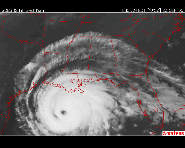
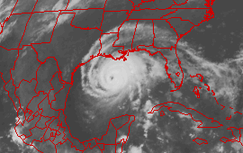
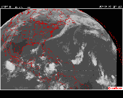
The tail of Rita as she moves out to sea
![]() INFORMATION WARFARE : ELECTROMAGNETIC WEAPONS
Jane's BUSH
NORTHCOM
INFORMATION WARFARE : ELECTROMAGNETIC WEAPONS
Jane's BUSH
NORTHCOM
9/24/2005 8:23:03 PM Pacific Standard Time
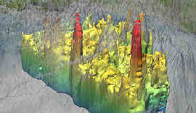
kent, whatever those 5 spots are, they definitely are not an artifact and they are the cause of rita turning north a few miles ahead of schedule. they seem to be directed from corpus christi. my presumption is that they are ships. we have high powered microwave weapons , ship mounted, in the 90-110 GHZ range which overlaps the radar freq. used in the animation. i worked on the first ones in 1983. contract was NSG through DOD. they heat a thin surface layer of any watery target (like raindrops-though that wasnt the original intent) they are aiming UP toward top of rita. you found a definite "something"
The Chief of Naval Research, RADM Jay Cohen, has established fleet-oriented priorities for ONR, including technologies for all-electric ships within the next ten years, producing electric-powered high energy laser and microwave weapons
September 24, 2005: The following [known] Navy ships were in the region: the Iwo Jima, the Shreveport, the Tortuga, the Grapple 2, the Patuxent and the Comfort SLEUTHS any additional ideas about ships?
![]()
9/24/2005 10:20:38 AM Pacific Standard Time
Kudos for the on-air mention by Richard C. Hoagland during the first hour of last night's show. Keep up the excellent research and investigations of the weather/radar anomolies. The four hot spots in the animation are strange indeed. Perhaps the newly unemployed weatherman from Idaho could help interpret. My speculation is that they are injected hot spots from HAARP or other electro/magnetic injection device. Is there a HAARP plot that might confirm its activity during that time?
![]()
9/25/2005 2:04:01 AM Pacific Standard Time
HURRICANE STEERING PRACTICE: A MANAGEMENT PROBLEM? *PIC*
Posted By: IZAKOVIC <Send E-Mail>
Date: Saturday, 24 September 2005, 1:23 p.m.
http://www.rumormillnews.com/cgi-bin/forum.cgi?read=79129
By now it should be clear to anyone that Rita is, definitely, a fluke. As far as grayops are concerned.
It brings up, again, a ground-level management problem that is slowly becoming a limiting factor of the whole operation.
As, at this stage, USAF's 2025 Owing The Weather technology is not good enough to, even, control the direction of hurricane, let alone it's strength, it's application at this stage is starting to generate emotional reaction at targeted populace that could bring the whole project down.
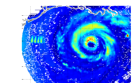
Image bellow, that is posted at Kent Stedman's Cyberspace Orbit site at
shows what statement above is about. You can see the sat Rita's image from Sept. 23 at 10:15:00. On the left site of this image you can see 5 large rectangular areas whose temperature is much higher than that of the surrounding atmosphere.
In remote viewing the object with right angles indicates an artificial structure. In this case heated-up rectangular areas indicate pockets of atmosphere, that were heated-up by HAARP, so the local air pressure would rise in attempt to steer Rita towards the opposite, lower pressure side, towards New Orleans that is visible on the right of the hurricane.
Perhaps Rita was supposed to take down New Orleans for good. Unfortunately, this time, the local (US) terror implementation practice efforts, that are in operation since 911 event, have, once again, failed.
----
IZAKOVIC
![]()
9/25/2005 10:07:34 AM Pacific Standard Time
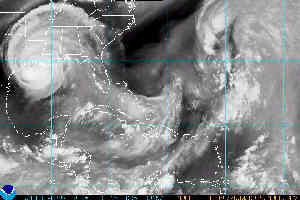
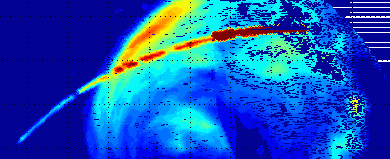
Take your time in looking at this. Give this some serious thought. Keep in mind also that everything pointed to a stalling of the storm some hours ago, but now it did not. Is it possible there are two different sources of modification here? I know this sounds crazy, but do you have an explanation?
before storm hit: last24hrsan.gif
Another before the storm hit: See the "foot prints"? sat_irscalar.gif
Look at this in its entirety ....current source:
http://cimss.ssec.wisc.edu/tropic/real-time/marti/2005_EIGHTEEN/webManager/basicGifDisplay.html
Kent, be sure and let that third URL here load all the way. It is just as impressive as your first find here. The impressive part will start showing up in the second half of this URL. I have saved the loop in case it is gone before you see it. It is amazing to me.
9/25/2005 1:12:44 PM Pacific Standard Time
WOW! looks like a different source all right. Well, we are in fact speculating on weather warfare! PUSH AND PULL!--Kent
![]()
9/25/2005 2:21:57 PM Pacific Standard Time
That is amazing, isn't it. I could not believe what I was seeing as that curved line appeared above the storm about where the front is on the third URL or the current one on the site at this date and time? If the front had continued on as expected, Rita would have stalled, and that is why the models all seemed to be projecting a terrible loop in the making. Some models even predicted that the storm might head off into Lousiana and loop back out over the Gulf, that is, until the front either slowed down or stopped.
Just speculation, but what if someone was able to cause intensification and another tried to hold back the norther to let the storm head off to the east? Or what if someone did not cause it, it was natural, but was able to "move" it off ot the right or force some dry air into is where the four thingys were? The dry air that was sucked into the southwest side was the saving factor. It caused the storm to not be a tremendous rainmaker or as intense. Could it have been possible Norad had the ability to help? Just speculation.....
![]()
9/25/2005 3:09:18 PM Pacific Standard Time
Kent,
Looking at http://cimss.ssec.wisc.edu/tropic/real-time/marti/2005_EIGHTEEN/webManager/mainpage.html and going through all the animations from Sept 19th 2005 onward I see what maybe further indications of steering or guiding.
You will have to look at the movies yourself as I don't have enough resources here to upload them.
Looking on the 19th and forward look for a cresent shaped signature first occuring in the mideastern side of Cuba, this cresent in furhter animations seems to track with the center of the tropical storm. It is the same type of cresent signature that is more or less fixed location in the movie from the 24th or25th. In the Sept20th movie this cresent remains fixed for a period of time across Cuba.
I am searching and veiwing all the animations available from the above said site to see what else is there and recommend the other sleuths also take a look and "save" these animations if at all possible in case they dissappear.
![]()
9/25/2005 1:00:53 PM Pacific Standard Time
Hi Kent.
We have some strange climatic changes in Brazil too.
In South and Center-West, low precipitation with problems to assist crops.
In Center-West we had problems with fire too.
In Southest [I live in Rio de Janeiro State] and Northest regions higher precipitation and floods.
In Santa Catarina and Rio Grande do Sul (States) we have in past year one phenomena like Hurricane in coast.
First observed in this states.
In Santa Catarina and São Paulo (States) we have frequent tornados.
About other countries.
In India, China, Australia and Middle Europe problems with flooding.
The technology sayed by USA over enviroment control is very interesting.
But i cant have in mind, why the government no protect the affected areas?
In Brazil we construct some big tanks of water to drain the excess of flooding (in the max).
[In São Paulo City we call it by name piscinão].
In the most common flooding they can suport the city with moderate flooding [non stoping services].
In areas of earth instability we construct structures to retain the earth.
We know that's changes in currents of heat in Atlantic Ocean can cause it.
I have in mind one film Day After Tomorrow, The (2004).
All the phenomena registred is very similar with the phenomena related in film.
Strange if the scientists report it in on a film, why nothing is made to modify it? Hum...
Our governments is more in center with your self than with population.
It's time to they make the paper of they.
![]()
9/25/2005 3:57:56 PM Pacific Standard Time
Further looking around at http://cimss.ssec.wisc.edu/tropic/real-time/marti/2005_17W/webManager/mainpage.html shows the same sort of thing, steerage or not, going on with this typhoon.
One does wonder what is being shown here for sure. Or how this works, or who if any one is doing it. But it does not seem to be only directed at the USA, in this case, China seems to be the "target" It looks as if temperature barriers were erected to contain the movement of this typhoon so that it could build up. If I find more examples of this then one may be able to see just how these horizonally polarized temperature arcs are influening the buildup movement and disappation of these storms.
Tropical Storm (formerly Hurricane) Kenneth also shows these same temperature arcs.
Are we sure these are not some kind of processing rendering artifacts?
Looking at Tropical Storm 18w from this site http://cimss.ssec.wisc.edu/tropic/real-time/marti/2005_18W/webManager/mainpage.html shows some of the same processes going on in it. Are these artifacts of some sort from the "morphing" rendering, or something else?
Both 17W and 18W bear closer observation over time.
 |
9/25/2005 4:11:20 PM Pacific Standard
Time
Requires follow up, do these artifacts disturb the structure of the storm in question? Does the storm change path?--Kent? |
![]()
9/25/2005 5:27:25 PM Pacific Standard Time
http://thewebfairy.com/fonebone/hurricane/
http://thewebfairy.com/fonebone/hurricane/GWEN.jpg
NOTE the FIVE GWEN TOWER locations in the map INDICATING tower placement ACROSS THREE STATES where the ELF DOMES are POSITIONED ABOVE FLORIDA
The ELF RADIATION HEATS THE AIR WHILE BOILING OUT ANY MOISTURE from ORGANIZED RAIN SYSTEMS within each dome's 200 mile footprint - Lines of GWEN towers steer the JET STREAM and block hurricanes
IN EFFECT the TOWERS FORM A "STATIONARY HIGH " ACROSS THE THREE STATE AREA ABOVE FLORIDA
The HURRICANE is BLOCKED FROM MOVING NORTH by the invisible GWEN ELF BARRIER
The barrier's actions on the hurricane can be seen however by comparing GWEN tower position and viewing this weather map -Fonebone
http://www.thewebfairy.com/fonebone/dispart.shtml?ID=74
http://www.thewebfairy.com/fonebone/dispart.shtml?ID=76
Fonebone is a telephone lineman from New Jersey. Currently he's on a crew getting phone service restored to Florida, I
believe.
http://thewebfairy.com/fonebone is various weather radars he has collected and explanations.
![]()
9/26/2005 6:36:44 AM Pacific Standard Time
Hi Kent_September 26, 2005
I went thru a long logical analysis of the weather wars situation, trying to figure out who was the Enemy. First, weather control requires huge energy sources. If Russia had cooked Rita, they would have been “quaked” by the US within 72 hours.
If it had been Yakuza, operating from a geothermal well in northern Japan, carrier-based US special ops would have erased them from the earth within 24 hours. Yesterday, Jim McCanney proclaimed our friend Scott Stevens to be a paid dis-info agent. I had to wonder about Scott leaving the day-job. And there are some that think Bearden is dis-info too.
That leaves either an evil cluster of the US military, or Amitakh Stanford’s alien wars. Perhaps they are the same thing.
Sure Rita was steered and cooked. (By the bad guys, US Army???) Then at the last minute we saw those “blobs” clearly pushing Rita away from Houston, toward rural small towns. (By the good guys, US Navy???)
Now if they were alien wars, how come there hasn’t been a counter-strike against some alien base in Europe or Asia, or to a space ship?
So we are back to the US military operating under evil control orders.
Whatever, we the little guys are so screwed.
![]()
9/26/2005 6:50:07 AM Pacific Standard Time
I decided that if there was an "EIGHTEEN" in the title URL, why wouldn't there be a "SEVENTEEN". I deleted the EIGHTEEN and placed in its place SEVENTEEN. Here is what I got:
http://cimss.ssec.wisc.edu/tropic/real-time/marti/2005_SEVENTEEN/webManager/basicGifDisplay.html
I only have dial up at my office and most likely will be interupted in trying to wait for the downloads, but I want you to work with me on this. I won't be on high speed til I get home this evening.
I would suggest you not tell anyone til you have time to download all the "numbers" before this one to see what we have found. IT may be nothing at all, but let's wait til we have seen all the others before this one before we tell anyone else. There is no telling what we will find. Ok?
I am downloading SEVENTEEN right now. Try to download ONE through SIXTEEN as soon as possible then SEVENTEEN also. I am assuming they will be informative too. I will contact you as soon as SEVENTEEN is through. If you have highspeed and see first, please tell me what you see. Go through all of them before showing anyone else, or we might lose access if it really is something and too many people start going to the URLs.
I did try placing the number ONE in the title and hit it just to see if it would work. It did. It looked to be a one of the hurricanes that hit Pennsacola earlier.
One of the links I went to showed Berkley labs involved in this URL. found looking for "Horizontal Polarization".
 |
9/27/2005 12:31:03 AM Pacific Standard Time
As long as the earth rotates from west to east, storms can only rotate counterclockwise in the atlantic, north of the equator- unless they are engineered. That one looks like it's turning clockwise. Too soon to know for sure--may be an optical trick. If not, every scientist on earth will be an instant convert. |
|
9/27/2005 8:49:38 AM Pacific Standard Time
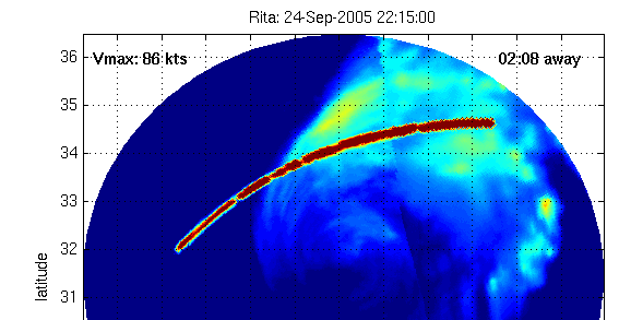
The Rita fragment at left should begin turning counterclockwise after it cannibalizes Rita fragment at right (which is still clockwise) it should become small but intense storm/'cane and hit Texas City, Texas about Saturday. Tropical storm at right could catch up to Rita Sunday. |
![]()
9/27/2005 7:35:30 AM Pacific Standard Time
Kent, When hurricanes are in their formation stages, you will usually see it develope under a upper level high pressure system which turns clockwise. I think they call them antyclyclonis air flow. I was fooled recently into thinking we had a storm developing in the lower gulf last month when I saw a cloud mass rotating counterclockwise. Turned out it was an upper lever low pressure. It was rotating counterclockwise but at a high altitude. A developing storms counterclockwise movement of storm clouds can be see as counterclockwise but it must be a lower altitude low pressure, so it can get its fuel from the water's heat. A higher altitude level high pressure will show clockwise but is not tapping into the water's heat.
Current:
![]()
 |
9/27/2005 1:44:39 AM Pacific Standard Time
Kent Another piece to add to the Rita collection. Wonder about the top-center "corridor" effect on this bitmap--especially considering the new 09-27-05 Rita reformation(?) pattern. |
![]() ACCUWEATHER ADRESSING RITA-BREAKAWAY
ACCUWEATHER ADRESSING RITA-BREAKAWAY
![]()
9/27/2005 6:02:30 PM Pacific Standard Time
I am not sure if you may recall, but last year after the hurricane, not sure the name, ripped through Florida, George made a speech with little brother standing by. I can't remember his exact words but they went a little something liket this "We need to be ready for an even worse season next year". Were we forwarned about the coming doom? Also, did you happen to catch the movie "Oil Storm"? Desensitizing the American public of the tradgedy that would soon follow as the greed for oil and money slowly destroy our freedom.
![]()
9/27/2005 6:28:32 PM Pacific Standard Time
"..Kent, When hurricanes are in their formation stages, you will usually see it develope under a upper level high pressure system which turns clockwise. I think they call them antyclyclonis air flow. I was fooled recently into thinking we had a storm developing in the lower gulf last month when I saw a cloud mass rotating counterclockwise. Turned out it was an upper lever low pressure. It was rotating counterclockwise but at a high altitude. A developing storms counterclockwise movement of storm clouds can be see as counterclockwise but it must be a lower altitude low pressure, so it can get its fuel from the water's heat. A higher altitude level high pressure will show clockwise but is not tapping intothe water's heat.
Current: ...."
9/28/2005 7:02:03 AM Pacific Standard Time
The blips you are calling 'Hotspots' are cold. On the MIMIC site the dark red colouring is cold - the dark blue is hot - just to confuse everyone! Does this make a difference as to what they are?
![]()
9/28/2005 6:57:33 AM Pacific Standard Time
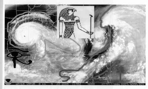
Hi Kent, Did anyone see this on crownweather.com? Is this the head and body of Ra pushing Rita into the Gulf which looked like the Eye of Ra? I didn't have to squint my eyes to see it it was there immediately when I pulled up the page. It blew my mind!
![]()
Some of you might want to look through some of this info as sent to me during the 9/11 investigations. Could such a platform include scalar weapons systems?
Well you cannot expect standard Commercial Airline Pilots to know about (CLASSIFIED). OPS BLACKSTAR is Highly Compartmented, Secret Fire-Command & Control Platform System that flies out of Holloman AFB NM./FT. Huachuca, AZ (BLACKBAG OPS). Combine BLACKSTAR (Pilotless) and Thiokol's Corps. Portal Transport Systems (illegally downloaded by Wen Ho Lee, at Los Alamos), and You can control ANY AIRCRAFT THAT IS FBW. Remember that OPS BLACKSTAR has broadcast dissemination capabilities to 100 Aircraft at one time (AWACS, ASARS, JSTARS, TENCAP, TROJAN SPIRIT, GUARDRAIL-CS, UAV's, SIGINT, TEAMMATE, TRACKWOLF, REMBASS, HUMINT, CI IMINT, MASINT, TECHINT, JTF, ARF-OR, ACE, JIC, ACT) for an effective INTELLIGENCE BOS. I have personally SEEN, OPS BLACKSTAR in operation.
![]()
 |
Caribbean Tropical system been turning clockwise [the wrong way] for days now. What the heck is going on? Look how the tail of Rita as she moves out to sea determines to stay connected to the Gulf Forum |
9/30/2005 5:12:44 AM Pacific Standard Time
As CSO has connected this info: The Elemental Spirits have left the Earth--in 2004. Therefore the elements --earth, air, fire and water --are not forced to behaving by laws that were guided by the Elemental Spirts. Storms can rotate opposite, rainbows can appear with the red on the inside of the bow. All elements are not behaving as they were under the Spirits Law. I had rain when the sky was perfectly clear--no clouds around and no wind--the rain just materialized. Any one seen any other examples???
Wow, awesome thought. On the other hand there is still whisperings of such things as the Jinn--Kent
![]()
10/1/2005 1:12:57 AM Pacific Standard Time
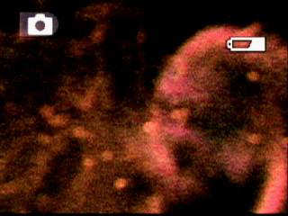
I think those "ships" are a BIG, BIG BEAM.
All I know is that EM targeted individuals are getting hit with a beam that entrains two strands of plasma that wrap around each other. The strands look like two strings of pearls until they get all wrapped around each other and become one strand.
"A strand of microplasma swirling into Frank's ear." from: www.msnusers.com/moratorium, courtesy of Frank Sablan
When the satellite cranks-up the pain levels go up, also (frequency), then the beam stretches out and starts to look like segments of a worm.
"Ambient temperature particle-ion beam." (in Frank Sablan's yard)
I think when plasma beam is going slow it looks more like a swirling beam -- going fast and stretched-out it looks more like segments of worms -- but it is really two streams of orb gas plasma (ionized gas) coupling, combining, and twisting around each other.
"Mind control pictures right to the optic nerve," courtesy of me, Carolyn Palit 2005
When the beam really gets "going," the beam straightens out and looks like one stream of plasma carried on an EM beam.
See, little beams cranked-up and looking like lined-up, donuts:
"My poor eyes!" from: www.noexoticwarfarezone.com, courtesy of me, Carolyn Palit 2005
Bigger donuts (bigger and more cranked-up beam):
"These two pink plasma donuts are really just a bigger beam -- larger diameter -- only caught part of it with the camera," courtesy of me, Carolyn Palit 2005
Something to do with attraction; the two streams couple and pull together into one stream. These orbs stick to the body. Magnetic polarity. I think they put plasma, negative particle-ion beams, and the idea of a frequency weapon together and came up with this diabolical weapon -- I think these weapons are on LEOs all over this earth.
"Beam coming out of an LEO at a targeted individual (TI) in North Carolina and hitting his car window," courtesy Ken Lee.
These weapons can work weather wars, mind control, send communications, or fry people and objects. It all depends on the frequency and the diameter of the beam.
BIG, BIG donuts lined-up (meaning a BIG, BIG BEAM that is really cranked-up) in this hurricane photo:
So much for The Republic, I think maybe it is pretty much dead.
peace, iceni6, Carolyn Palit
![]()
10/2/2005 8:16:57 AM Pacific Standard Time
kent,
a hurricane is a cyclone or typhoon in the caribbean- now extended to include part of south atlantic.
a hurricane is a tornado large enough to be dominated by coriolis force
.
numerous large tornadoes can merge into a hurricane.
95% of N hemisphere tornadoes are CCW {counterclockwise}
CW N hemisphere tornadoes can only form as a twin of CCW tonadoes
it is possible for a N hemisphere, SMALL ,CW hurricane to form as a twin of a CCW hurricane, but this has never been observed- not even one time.
no "cyclone" {of which "hurricane" is a subset} has ever crossed the equator because no Coriolis force exists at the equator
http://www.metoffice.gov.uk/sec2/sec2cyclone/catarina.html
Question remains then what force is imposed?--Kent
low pressure troughs follow hot spots in ionosphere. hot spots can be formed by masers lasers and radio waves- and have been for 50 years. nothing mysterious. the pompous gibberish just makes it impossible to explain anything.
postscript
last night the ionospheric hot spot was established over slidell, louisiana. i dont know who is doing it but it requires huge amounts of radio energy- megawatts. the US gov is aware of every radio signal on the globe at all times.
if the heating persists stan will strengthen and land at NO.
10/6/2005 9:49:26 AM Pacific Standard Time
Kent,
Are you yet aware of strange developments concerning the "tiger stripes" in the Hurricane Rita MIMIC animations that you first brought to peoples' attention?
For some reason the "tiger stripes" have been edited (airbrushed) out of the MIMIC animated GIFs for Hurricane Rita. There are just a few frames remaining of when the stripes were first beginning to form and are not very noticeable. After that it's all gone.
At the moment the "tiger stripes" are the only anomalies that have disappeared from the MIMIC records of recent Hurricanes.
I'm sure they would give some soothing reason for altering the presentation of the data in this way. However, I think it is a fair bet that if you hadn't made such a fuss of the "tiger stripes" GIF that it would still be displaying in an "uncorrected" format. :)
Really it would have been more professional of them to have added a note to the MIMIC history page for RITA explaining that they had made changes and the reasons for doing so. That is the common practice when official statistics are revised.
The image alterations came straight after this intriguing story appeared on the internet.
http://rawstory.com/news/2005/Commerce_Department_tells_Nationa_1004.html
Best Regards,
NOTE: Commerce Department tells National Weather Service media contacts must be pre-approved
The "airbrushing" out of the anomalies in the MIMIC animation of hurricane Rita was the important thing that I wanted to bring your attention - just in case you were unaware of it. It is a very strange development in the story.
ADDITIONALLY
Kent,
The soothing explanation has duly arrived on the MIMIC web pages.
http://cimss.ssec.wisc.edu/tropic/real-time/marti/gallery/galleryRita0.html
"Disclaimer: It was brought to our attention that this original animation of Hurricane Rita showed an anomalous red patch (often referred to as the "red fingers") to the west of the storm around the posted time of 09/23/05 1315 UTC. We have examined the original source of the data and established that this feature is the artifact of a transmission error in the DMSP-13 satellite (several brightness temperature values are negative, for example) that was extrapolated across a data gap in the imagery. The feature appeared to last for several hours because the algorithm that generates this data works by blending entire images - including their bad data - into one another over the span of several hours."
HUH? Well soothing, right. Did they notice that these glitches also magically busted up the storm on its western limb as seen on UNISYS IR? Also what's the jargony explanation for this:
Additionally, take a look over here: Although less compelling because not overall not that unusual [interference happens often] but I'm wondering about certain interference patterns on the IR sat, seen it duplicated over the Pacific... under similar situations... which grabs my attention!
![]()
From "Jim Teet" XXXXX@noaa.gov
Date Thu, 29 Sep 2005 12:04:34 -0600
To _NWS WR WFO MICs wr.wfo.mics@noaa.gov, _NWS WR WCMs wr.wcms@noaa.gov
Subject DOC Interview Policy
Good Day All:
I have been informed that any request for an interview with a national media outlet/reporter must now receive prior approval by DOC. Please ensure everyone on your staff is aware of this requirement.
Any request for an interview requires the following information to be forwarded to me immediately, so this process may begin:
The name of the reporter and their affiliation; Their deadline and contact phone number; Name of individual being requested for the interview and purpose of the interview; Additional background about the interview subject, and expertise of requested interviewee on this subject.
The request will be forwarded through NWS/NOAA to DOC; however, the individual to be interviewed ultimately will be determined by DOC.
If any requests for an update concerning the interview are received from the media, refer the individual to me for a response via my cell phone: (XXX) XXX-3516.
Thanks, Jim Teet
![]()
ADDITIONAL CONSIDERATIONS
South Atlantic Hurricane breaks all the rules
Experts: Future of Big Hurricanes Looms
Spin>>
|
|
Caribbean Tropical system been turning clockwise [the wrong way] for
days now. What the
heck is going on? Mutating now into
TROPICAL
STORM STAN
2 Forum
2
3
Super Typhoon Longwang 2 3 Landfall 23Typhoon Longwang Lashes Taiwan, Threatens China Hurricane Otis 2 Trop Nineteen 2 |
|
SCOTT STEVENS INTERVIEWS www.weatherwars |
LISTEN
UPDATE:
|
Massive Hot Spot in Southern Gulf of Mexico!

![]() Hurricane
Rita Discussion Number 15 Statement as of 5:00 am EDT on September 21,
2005...the reconnaissance mission scheduled
for this morning was scrubbed due to electronics problems on multiple
aircraft.
Hurricane
Rita Discussion Number 15 Statement as of 5:00 am EDT on September 21,
2005...the reconnaissance mission scheduled
for this morning was scrubbed due to electronics problems on multiple
aircraft.
Mysterious 'Ball Of Fire' Seen In Fla. Skies Synch Premier of Invasion NASA: ´Huge Flaming Ball´ Might Have Been an Asteroid
Control Aerodynamics from Space
|
What these generated control fields do is increase or decrease all of the binding forces of Nature, with their vortex radiated actions, the most stable, natural form of the Control Electomagnetic field is the binding energy in the nuclei of all atomic elements, the so-called strong nuclear force. Both the strong and weak nuclear forces are products of Control Field actiions. In the nuclei of atoms; the motions of the protons and neutrons produce a very strong, local control field binding energy. All the forces of nature are part of the REAL electromagnetic, dynamic system |

